• There seems to be an uptick in Political comments in recent months. Those of us who are long time members of the site know that Political and Religious content has been banned for years. Nothing has changed. Please leave all political and religious comments out of the forums.

    If you recently joined the forums you were not presented with this restriction in the terms of service. This was due to a conversion error when we went from vBulletin to Xenforo. We have updated our terms of service to reflect these corrections.

    Please note any post refering to a politician will be considered political even if it is intended to be humor. Our experience is these topics have a way of dividing the forums and causing deep resentment among members. It is a poison to the community. We appreciate compliance with the rules.

    The Staff of SOH

  • Server side Maintenance is done. We still have an update to the forum software to run but that one will have to wait for a better time.

Curious...

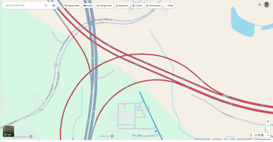
Also curious - this time about map data. If you spawn at KGSO and fire up the drone, then go straight up a hundred feet or so, you can see a red/white water tower off to the northwest. In the real world, there are roads including an interstate highway, that run around that tower that don't exist in the 2020 sim - see the roads in red in my attachment. But here's the strange part. If you take that drone out to the tower and watch the cars, they're there, driving on invisible roads. And in the case of the ramp from I73 West to 68 South, which is elevated, you'll see cars driving across the tops of the trees. I'd like to know if 2024 finally gets this section right, or if they're still using the same map data from 2020.
KGSO Roads.png
 
Back
Top