• There seems to be an uptick in Political comments in recent months. Those of us who are long time members of the site know that Political and Religious content has been banned for years. Nothing has changed. Please leave all political and religious comments out of the forums.

    If you recently joined the forums you were not presented with this restriction in the terms of service. This was due to a conversion error when we went from vBulletin to Xenforo. We have updated our terms of service to reflect these corrections.

    Please note any post refering to a politician will be considered political even if it is intended to be humor. Our experience is these topics have a way of dividing the forums and causing deep resentment among members. It is a poison to the community. We appreciate compliance with the rules.

    The Staff of SOH

  • Server side Maintenance is done. We still have an update to the forum software to run but that one will have to wait for a better time.

Dewey Moor airstrip in Idaho, I don't think so.....

limjack

Charter Member 2016
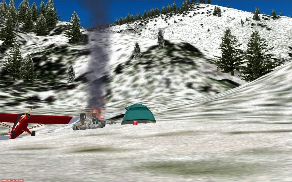
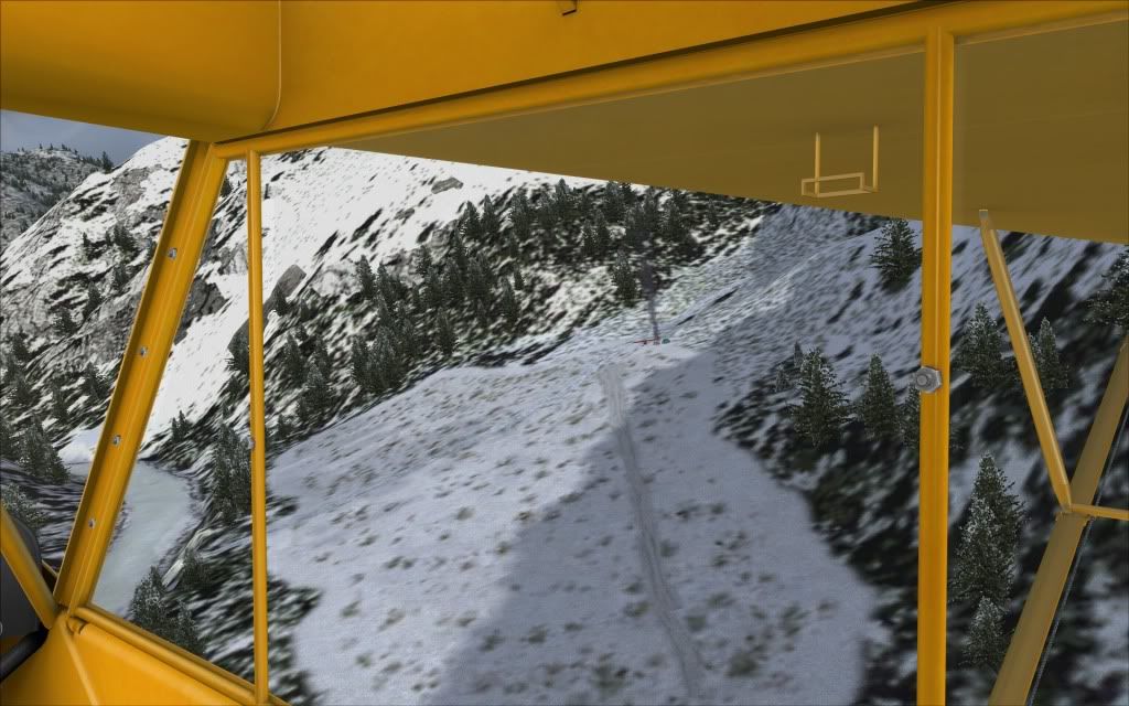
I did not find this airstrip. Folks on another forum where talking about it so thought I would give it a shot and share as well for those who seek a tough challenge. Not sure if it is a default runnway in fsx or part of one of orbx scenery packages. It has an uphill landing strip. I did take off ok but not even close on the landing. Crashed and burned....Add me to the campfire at the end of the runway along with my remains. Can't believe people really fly into this strip. I would be heaving and saying my prayers beacause to me this is just sudden death.

http://www.youtube.com/watch?v=8vlR1juKQoY


Here is a pick of strip from FSX


2011-11-6_8-8-26-754.jpg
 
Good find, that's on my list for trying out this pm. IRL you would have to have supreme confidence that the airstrip is clear of boulders/wildlife etc....
 
I kept watching the video as he got lower and lower, wondering where's the airstrip, then suddenly he was on it. I'd give it a shot in FS but no freakin' way would I attempt it in real life. With luck they'd find my remains in the spring. :icon_lol:
 
LOL....at least someone made it. They are using my piper to feed the fire...sorry A2A. Will have to try that landing again.

2011-11-6_10-57-40-415.jpg
 
You'd probably like "Mile Hi" instead...
Just don't strike your prop! :mixedsmi:

<iframe src="http://www.youtube.com/embed/p7-QbI9Qzeg?rel=0" allowfullscreen="" frameborder="0" height="360" width="480"></iframe>
 
In the first video, as he comes to a stop, is that another cub sitting down in the ravine below him? lol
 
In the first video, as he comes to a stop, is that another cub sitting down in the ravine below him? lol

Sure does look like some sort of plane but looks really small.

Jim
Ooops, I was looking down by the water. Looks like a plane but i am sure I am just seeing things.

plane.jpg
 
He's traveling up a hill, so the other cub is just parked on a level area of ground, which is actually positioned above the end of the runway.
 
I made my voyage to that strip when CRM first came out, was actually my first salmon river landing after taking off from McCall ( I then visited most of the other strips in the area) I aborted six times before being able to land and the landing was NOT a pretty one. I stalled a few feet AGL and bounced the tundras on the scout pretty well as I recall. if you compare the youtube vid from the sim, there are some big differences. the "runway" in orbx starts well before you see the plane landing in the video, so do not try to aim for the first part of the runway, you should land actually pretty well up the hill as you can see in the vid and then hopefully stop before taking out the happy couple by the fire. Once you do this one, the other salmon river strips are pretty tame by comparison, but still fun, this one isn't. I did this in a real air scout, the best would probably be FR supercub. I wouldn't try it in the A2A cub though, I need my flaps for this sort of stuff.

FWIW I remember reading a post on youtube from a presumably RL Idaho pilot who said that Dewey Moore IRL was "easy". Doesn't look like it to me.
 
<iframe width="560" height="315" src="http://www.youtube.com/embed/djI2pwXXppc" frameborder="0" allowfullscreen=""></iframe>

Here's the Cocky B@%#$@rd lol
 
I just tried landing at this airstrip in FSX and all I can say is the pilots that have done this in real life either have some serious guts and skill or they're plain crazy(pun intended)!
 
Since I started doing a lot of Bush Flying (I have PNW and Pacific Fjords) I decided to give these a try. I flew into both of them using several different airplanes just to see the advantages of one over the other. In that same general vicinity there are 5 small strips that make it easy to get from one to the other in quick succession: Root Ranch which is 12nm north of Dewey, Cold Meadow also 12nm north, then there's Big Creek 12.5nm west and Mile High which is around the corner, lol at 3nm. I had no problems landing at any of them using both the Husky (thanks Steve Grant) and the Bush Hawk by Aerosoft (beautiful little airplane) using Summer as the season, thinking the trees would make it more difficult to spot and land. You can't come in hot to any of these except Big Creek, that one has a rwy a mile long, or at least it seems that way after landing at the others. The remaining 4 needed speeds just above stall to get stopped and none of them (Mile High or Dewey) had the inclines that they have in real life. I did not find any of them to be terribly difficult to land at, but because you're doing Mountain/Valley Flying, they do come up on you pretty quick and if your airspeed isn't already set for landing, you won't have time to slow down and land. . . .just my opinion.
 
Hi falcon409,

note that while those airstrips you mention exist in FSX default they are perfectly flat with oversized grass skirtings and runways as is typical for small default airstrips. It's the ORBX Central Rockies package that gives them correct dimensions and slopes (well, as correct as the ancient USGS elevation data allows).

Cheers, Holger
 
I've been to a lot of Idaho's backcountry strips in real life.
They are not that bad to get in and out of. No, really.
In fact it's quite fun to do a tour on a lazy summer day.
But obviously you do need to have experience in back country flying, grass/dirt runways, the right airplane, and good skills in operating the proper aircraft for the strip.
As it has been said, "A man's just got to know his limitations". :wavey:


McCall Idaho (KMYL) is one of the aerial depots for the United States Forest Service (USFS) and home to a Smokejumper base.
You want to ratchet it up a notch, you could always operate a Twin Otter out of many of these strips like the USFS does. :icon_lol:

(I do love the audio on this one!)

<iframe src="http://www.youtube.com/embed/jY-xe9T3KMo?rel=0" allowfullscreen="" frameborder="0" height="360" width="640"></iframe>
 
Hi falcon409,

note that while those airstrips you mention exist in FSX default they are perfectly flat with oversized grass skirtings and runways as is typical for small default airstrips. It's the ORBX Central Rockies package that gives them correct dimensions and slopes (well, as correct as the ancient USGS elevation data allows).

Cheers, Holger
Now you've done it Holger, lol, that means I've gotta pony up for yet another huge download, lol.:salute:
 
I've been to a lot of Idaho's backcountry strips in real life.
They are not that bad to get in and out of. No, really.
In fact it's quite fun to do a tour on a lazy summer day.
But obviously you do need to have experience in back country flying, grass/dirt runways, the right airplane, and good skills in operating the proper aircraft for the strip.
As it has been said, "A man's just got to know his limitations". :wavey:


McCall Idaho (KMYL) is one of the aerial depots for the United States Forest Service (USFS) and home to a Smokejumper base.
You want to ratchet it up a notch, you could always operate a Twin Otter out of many of these strips like the USFS does. :icon_lol:

Man, that just looks like so much fun. Awesome, thanks for posting!!
 
Kinda disappointed the Allison Ranch (ID08) never made it into Orbx CRM, I thought that would have been a "gimme". :kilroy:
Yellow Pine Bar did, which is just a couple miles or so SW of the Allison Ranch however.

Allison Ranch is used for training MAF pilots for a very short turn to final on remote strips.
You don't have any choice, its fly down the Salmon River canyon, then a quick sharp left turn to the threshold.
Don't know if they still do, but Quest used to use it for Kodiaks too.

<iframe src="http://www.youtube.com/embed/0bC4wE7Uues?rel=0" allowfullscreen="" frameborder="0" height="360" width="480"></iframe>

<iframe src="http://www.youtube.com/embed/uQ_mciV6AvE?rel=0" allowfullscreen="" frameborder="0" height="360" width="480"></iframe>
 
Had a few extra bucks and decided to grab the Rockies scenery so I could see what everyone else is seeing with the aforementioned strips. Made the purchase, downloaded, installed, went to a start strip, but oddly it didn't seem to look any different, probably just my imagination, I thought. Flew to Mile Hi, no difference, hmmmm. Flew over to Dewey, the same perfectly flat, easy to land airstrip. I checked the installation, everything was correct. I loaded Google and checked the coverage area and my, my, my. I bought the wrong section of the Rockies. I have the Northern Rockies and that scenery stops about 40nm north of these air strips, lol. I needed the Central Rockies. If I had read previous posts (which I did) and paid attention to the abbreviations (which I did not) I would have known which one to get. Oh well!!
 
Had a few extra bucks and decided to grab the Rockies scenery so I could see what everyone else is seeing with the aforementioned strips. Made the purchase, downloaded, installed, went to a start strip, but oddly it didn't seem to look any different, probably just my imagination, I thought. Flew to Mile Hi, no difference, hmmmm. Flew over to Dewey, the same perfectly flat, easy to land airstrip. I checked the installation, everything was correct. I loaded Google and checked the coverage area and my, my, my. I bought the wrong section of the Rockies. I have the Northern Rockies and that scenery stops about 40nm north of these air strips, lol. I needed the Central Rockies. If I had read previous posts (which I did) and paid attention to the abbreviations (which I did not) I would have known which one to get. Oh well!!

Ouch. :isadizzy:

My opinion is biased, but you still got a nice section of the virtual Earth to fly in.
Northern Idaho and Montana have some interesting strips as well, especially if you fly around the Kalispell/Flathead Lake region.
There are a lot of strips in that area.
Then you can always go north from there and explore the Canadian Rockies.

NRM does dovetail nicely with CRM, if you can ever swing it, both are worth having. :wavey:
Yep, I agree Dain, It's something I would have purchased sooner or later anyway. I'll just have to save those pennies and get the Central Rockies next month.:salute:
 
Back
Top