• There seems to be an uptick in Political comments in recent months. Those of us who are long time members of the site know that Political and Religious content has been banned for years. Nothing has changed. Please leave all political and religious comments out of the forums.

    If you recently joined the forums you were not presented with this restriction in the terms of service. This was due to a conversion error when we went from vBulletin to Xenforo. We have updated our terms of service to reflect these corrections.

    Please note any post refering to a politician will be considered political even if it is intended to be humor. Our experience is these topics have a way of dividing the forums and causing deep resentment among members. It is a poison to the community. We appreciate compliance with the rules.

    The Staff of SOH

  • Server side Maintenance is done. We still have an update to the forum software to run but that one will have to wait for a better time.

Global Surface Water

Good news and bad news.

Here's the good news:
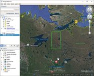
2812_vtp_8:

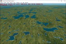
The BLN file is 71.7 MB, the resulting SBX file from SBuilder is 165 MB. The bgs file created by cfs2autocoast is 669 MB! The compilation took 9hrs. and 20 minutes, and BGLC_9 used upwards of 2.5 GB of memory in producing the shoreline BGL. 2812_vtp_8.bgl is 49.9 MB . CFS2 displayed the BGL just fine, with no noticeable drag on my FPS. Admittedly, I have a pretty good PC.

The bad news:

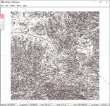
Cfs2autocoast introduces many anomalies... odd straight lines cutting through the scenery. Another approach is needed. Perhaps automated shorelines are not going to happen, and we'll still be drawing them all by hand. I'm working on a way to convert BLN shoreline files to G2Kv4 LWM files. If Ground2K can handle the massive size of some of these BLNs, BGLC_9 can compile the resulting assembly files.
 
Partial vtp shoreline success

I recalled a conversation with Sander in which he was surprised that he had anomaly free success when all lines were 2 points.

This is still the case as far as I can tell. I need to revisit my program to delete the hooks slartibartfast creates, and 'explode' the lines to 2 points. not the best, but if it works, I should be able to get some shorelines.
 
Dick

That is encouraging. Best of luck and thank you so much for all this hard and painstaking work.

We'd better get started on that shrine to you :ernaehrung004: :adoration:
 
Flattens would still be needed in some Area16n flattens areas. As far as anomalies in the vtp lines, I haven't been able to pre-process the BLN files to eliminate them entirely, and I even managed to get uncompilable BLNs.:dizzy: :pop4:

I'm not sure we are using the same version of Sander's program, but the odd lines are generated by CFS2AutoCoast 3.0.5004.18489

I have the same version of CFS2 Autocoast, can't say I noticed artifacts or anomalies when transferring FS9 bgls & converting (which is what this version was "optimised" for), so I wonder if running bgl through your VTP fixer post bgl generation works?
 
GSW Shorelines

My computer has been grinding out some Global Surface Water shorelines. I'm doing the whole earth.

Sander's Cfs2Autocoast has been a champ! The batch file has been processing the earth for about 24 hours. The biggest file so far is 1708_vtp_vtp_8.BGL (Sorry about the redundancies in the file name). It's in northern Canada, of course. Most of the world's lakes and rivers are there. The center of that file is around N65 W115.

attachment.php


The file is large. Over 34MB compiled. The .bgs file pre-compiled was 464MB.

attachment.php


This one file took about 3 hours to compile. So, it will take a few days to do the whole set. There will be some anomalies, but most not noticeable. Hopefully no crashes. All the shorelines are white sand. Not much I can do about that right now, but the SBX files may allow some editing in SBuilder for 2004. I haven't tried to eliminate the anomalies pre-processing as they are slippery devils, and often the cure is worse than the original error. As nice as Sander's program is, it still needed some tweaking.

I may get a Sbx2G2k program working. That might allow a different approach to making some adjustments. Or it might be a new hell-on-earth. :)

attachment.php


I'll check back in a few days when the compiling is done, and see how CFS2 likes the huge collection of gigantic files.

I had to write a program to convert the BLN files from Slartibartfast to SBuilder9 SBX files. That worked well.
 

Attachments

  • 1708.jpg
    1708.jpg
    124.7 KB · Views: 84
  • 1708_vtp_8.jpg
    1708_vtp_8.jpg
    170 KB · Views: 82
  • in_1708.jpg
    in_1708.jpg
    106.1 KB · Views: 82
Great stuff Ricardo!

Very nice to have accurate water, so thanks for all the effort, and thank your pc as well...

Oh btw does it take into account global warming.....:sorrow:

Cheers

Shessi
 
Great stuff Ricardo!

Very nice to have accurate water, so thanks for all the effort, and thank your pc as well...

Oh btw does it take into account global warming.....:sorrow:

Cheers

Shessi
Possibly!

The data is compiled by comparing 32 years of satellite data:

https://global-surface-water.appspot.com/download

I used "transitions" data and added the OSM Oceans data to it, to help with ocean abnormalities caused by clouds, ice and waves.
 
Can anyone tell when this would be available with a readme to install and use for simple minds like mine? ( VTP's;Regional scenery folder, etc. :dizzy:) :playful:
 
in Addon Scenery, I make a folder named 'GlobalSurfacewater'. Inside GlobalSurfaceWater, I make a folder named 'scenery'. I place all the GSW water lwm files, and all the excludes, and all the GSW shoreline vtp files into scenery.
I add it to the Scenery Library in CFS2, and activate it.
Done.

The shorelines should be available in about a week (I hope).
 
Simple enough. the "add-on" folder is something I never bothered to think about using.:kilroy:
Looking forward to all the great "eye candy" this will bring. I don't have a clue as to what you guys have been communicating with each other and don't intend to learn at this stage in my life!:wavey:
 
Simple enough. the "add-on" folder is something I never bothered to think about using.:kilroy:
Looking forward to all the great "eye candy" this will bring. I don't have a clue as to what you guys have been communicating with each other and don't intend to learn at this stage in my life!:wavey:

You can probably use the cfs2 main folder or the scenedb folder.

My sentiments exactly HP. I'll just stick to mission building... As Odd Ball once said: "Like, uhh... I just ride em man, I don't know what makes em go!"

I too am looking forward to the release.
 
I'm getting a slight reality check while doing this. The compilation of the VTP BGLs is taking much longer than I assumed. I have a fairly up to date computer, but BGLC, the compiler, is bogging down under the load of the Canadian wilderness.

It's going to be 2-3 months before the shorelines are done. But if there are no power outages, and my CPU, memory, and hard drive all hold up it will get done. I've been working on this project since August of 2018, so a couple of months is OK with me. The computer is running 24/7 at 4.23Ghz!

For those that have Sander's CFS2Autocoast, I'm going to store the vtp SBX files online later today. This would allow you to play with different shoreline textures, or figure out how to eliminate anomalies or hooks at the ends of the lines. SBuilderX 315 can Import the SBX files, if some splitting of the files is needed. That version can then export as bln or Luis Sa made a SBX version converter that will make a readable fs2009 SBX file. I mention this because the size of some of these SBX files will choke SBuilder9.

If you are more technically inclined, SBuilderX can export ESRI shape files, and those can be exported to a GIS program for work. I have GpsMapedit v.2.1 which can export an MP file that SBuilder9 can load directly. QGIS is also a great GIS program.
 
I found a missing watermask for the GlobalSurfaceWater_East set:

GSWCFS2_6316_lwm.bgl

It has been added to the Google Drive download or may be downloaded separately as above.

This is an odd area. Going to N45 E60 there is a mesh anomaly. And the landclass needs serious reworking as the Aral sea has dried up! Not sure what it looked like in 1938.
 
Last edited:
GSW ShoreLines

Here's the Google Drive link to the shorelines:

GSW ShoreLines

They are unfiltered and not reworked at all. There are anomalies, they are all 20 meters wide, and they all use the same tropical shoreline texture.

This should give us a good point of some reworking of the lines. Ground2K v4 might be the tool to use... take an LOD8 area at a time?

Jim Kier's LWMViewer can get a single cell's bitmap of the watermasks or the shorelines.

Stream lines are going to always be a problem. They need to conform to the mesh, or they run uphill in spots. Even FSX had the streams wrong. ORBX solved their vector problems by not having any streams... they just allow what was already in FSX or P3D. P3d streams seem better. The OSM data for streams isn't very good. Slartibartfast does have a way to generate streams, but I haven't tried it.

Landclass is a problem. It needs updating for all areas to insure coverage of the land masking. It can also be split into regions for better texture options. I may go there next.
 
I would prefer to have streams running up hills than to not have them at all. They can always be fixed with flatten files if necessary.

Keep up the good work!
 
Landclasses and Regions

I've completed the landclasses to match the Global Surface Water sets. I have arranged them into Regions. They are Region_A through Region_Z, and are roughly the same as found in FSX and P3D. Each region needs a full set of landclass textures to display properly. These are included in the download. Each region should be separately entered into the Scenery Library.

The textures in each region can be changed to reflect the different part of the world it represents. This gives us the ability to have different texture sets in each area of the world. For seasons, you'd need to have separate seasonal installs of CFS2, as is usual.

Regions.zip

The file is big. Around 1GB. That's due to the redundant texture files in each region's texture folder.

Dick
 
How I'm Set up for scenery

This is my Addon Folder:

attachment.php


This is my Regions folder:

attachment.php


Here's my scenery.cfg:

Code:
[General]Title=CFS2 World
Description=CFS 2 Scenery data
Cache_Size=100M
Clean_on_Exit=TRUE


[Area.001]
Title=Default Scenery
Local=scenery
Active=TRUE
Layer=2
Required=TRUE
Remote=


[Area.002]
Title=Terrain
Local=Scenedb\world
Active=TRUE
Texture_ID=1
Layer=1
Required=TRUE
Remote=


[Area.003]
Title=CFS1 Library
Local=Scenedb\library
Active=TRUE
Layer=3
Required=FALSE
Remote=


[Area.004]
Title=Airport Facilities Data
Local=Scenedb\AFDFiles
Active=TRUE
Layer=4
Required=TRUE
Remote=


[Area.005]
Title=Scenery Ships
Local=Scenedb\Ships
Active=TRUE
Layer=5
Required=FALSE
Remote=


[Area.006]
Title=Aircraft Weapons
Local=Scenedb\weapons
Active=TRUE
Layer=6
Required=TRUE
Remote=


[Area.007]
Title=Vehicles
Local=Scenedb\veh
Active=TRUE
Layer=7
Required=TRUE
Remote=


[Area.008]
Title=Effects
Local=Scenedb\fx
Active=TRUE
Layer=8
Required=TRUE
Remote=


[Area.009]
Title=Runways
Local=Scenedb\runways
Active=TRUE
Layer=9
Required=TRUE
Remote=


[Area.010]
Title=Buildings
Local=Scenedb\inf
Active=TRUE
Layer=10
Required=TRUE
Remote=


[Area.011]
Title=FS2000_props
Local=Scenedb\fs2kprop
Active=TRUE
Layer=11
Required=TRUE
Remote=


[Area.012]
Title=mesh
Local=ADDON\mesh
Active=TRUE
Required=FALSE
Layer=12
Remote=


[Area.013]
Title=Region_A
Local=ADDON\Regions\Region_A
Active=TRUE
Required=FALSE
Layer=13
Remote=


[Area.014]
Title=Region_B
Local=ADDON\Regions\Region_B
Active=TRUE
Required=FALSE
Layer=14
Remote=


[Area.015]
Title=Region_C
Local=ADDON\Regions\Region_C
Active=TRUE
Required=FALSE
Layer=15
Remote=


[Area.016]
Title=Region_D
Local=ADDON\Regions\Region_D
Active=TRUE
Required=FALSE
Layer=16
Remote=


[Area.017]
Title=Region_E
Local=ADDON\Regions\Region_E
Active=TRUE
Required=FALSE
Layer=17
Remote=


[Area.018]
Title=Region_F
Local=ADDON\Regions\Region_F
Active=TRUE
Required=FALSE
Layer=18
Remote=


[Area.019]
Title=Region_G
Local=ADDON\Regions\Region_G
Active=TRUE
Required=FALSE
Layer=19
Remote=


[Area.020]
Title=Region_H
Local=ADDON\Regions\Region_H
Active=TRUE
Required=FALSE
Layer=20
Remote=


[Area.021]
Title=Region_I
Local=ADDON\Regions\Region_I
Active=TRUE
Required=FALSE
Layer=21
Remote=


[Area.022]
Title=Region_J
Local=ADDON\Regions\Region_J
Active=TRUE
Required=FALSE
Layer=22
Remote=


[Area.023]
Title=Region_K
Local=ADDON\Regions\Region_K
Active=TRUE
Required=FALSE
Layer=23
Remote=


[Area.024]
Title=Region_L
Local=ADDON\Regions\Region_L
Active=TRUE
Required=FALSE
Layer=24
Remote=


[Area.025]
Title=Region_M
Local=ADDON\Regions\Region_M
Active=TRUE
Required=FALSE
Layer=25
Remote=


[Area.026]
Title=Region_N
Local=ADDON\Regions\Region_N
Active=TRUE
Required=FALSE
Layer=26
Remote=


[Area.027]
Title=Region_O
Local=ADDON\Regions\Region_O
Active=TRUE
Required=FALSE
Layer=27
Remote=


[Area.028]
Title=Region_P
Local=ADDON\Regions\Region_P
Active=TRUE
Required=FALSE
Layer=28
Remote=


[Area.029]
Title=Region_Q
Local=ADDON\Regions\Region_Q
Active=TRUE
Required=FALSE
Layer=29
Remote=


[Area.030]
Title=Region_R
Local=ADDON\Regions\Region_R
Active=TRUE
Required=FALSE
Layer=30
Remote=


[Area.031]
Title=Region_S
Local=ADDON\Regions\Region_S
Active=TRUE
Required=FALSE
Layer=31
Remote=


[Area.032]
Title=Region_T
Local=ADDON\Regions\Region_T
Active=TRUE
Required=FALSE
Layer=32
Remote=


[Area.033]
Title=Region_U
Local=ADDON\Regions\Region_U
Active=TRUE
Required=FALSE
Layer=33
Remote=


[Area.034]
Title=Region_V
Local=ADDON\Regions\Region_V
Active=TRUE
Required=FALSE
Layer=34
Remote=


[Area.035]
Title=Region_W
Local=ADDON\Regions\Region_W
Active=TRUE
Required=FALSE
Layer=35
Remote=


[Area.036]
Title=Region_X
Local=ADDON\Regions\Region_X
Active=TRUE
Required=FALSE
Layer=36
Remote=


[Area.037]
Title=Region_Y
Local=ADDON\Regions\Region_Y
Active=TRUE
Required=FALSE
Layer=37
Remote=


[Area.038]
Title=Region_Z
Local=ADDON\Regions\Region_Z
Active=TRUE
Required=FALSE
Layer=38
Remote=


[Area.039]
Title=Exclude_Default_VTP
Local=ADDON\Exclude_Default_VTP
Active=TRUE
Required=FALSE
Layer=39
Remote=


[Area.040]
Title=Global Surface Water
Local=ADDON\Global Surface Water
Active=TRUE
Required=FALSE
Layer=40
Remote=


[Area.041]
Title=GSW ShoreLines
Local=ADDON\GSW ShoreLines
Active=TRUE
Required=FALSE
Layer=41
Remote=

Dick
 

Attachments

  • AddonFolder.png
    AddonFolder.png
    28.2 KB · Views: 29
  • RegionsFolder.jpg
    RegionsFolder.jpg
    46.4 KB · Views: 29
Back
Top