-
There seems to be an uptick in Political comments in recent months. Those of us who are long time members of the site know that Political and Religious content has been banned for years. Nothing has changed. Please leave all political and religious comments out of the forums.
If you recently joined the forums you were not presented with this restriction in the terms of service. This was due to a conversion error when we went from vBulletin to Xenforo. We have updated our terms of service to reflect these corrections.
Please note any post refering to a politician will be considered political even if it is intended to be humor. Our experience is these topics have a way of dividing the forums and causing deep resentment among members. It is a poison to the community. We appreciate compliance with the rules.
The Staff of SOH
You are using an out of date browser. It may not display this or other websites correctly.
You should upgrade or use an alternative browser.
You should upgrade or use an alternative browser.
Papua New Guinea Redux
- Thread starter rbp71854
- Start date


Pat Pattle
SOH-CM-2025
Excellent news Bob! If I can be of any assistance with the airfields etc let me know.
Love that RAAF poster!
Love that RAAF poster!
rbp71854
PTO Solomons ,PTO Rising Sun, ETO Expansion
 The recruiting poster these days would be considered highly offensive to the ladies.
Thanks Clive for the generous offer. Of course I can use the help in the airfield area. I have maps, sketches, and data on most of the airfields. A lot of the airfields were marsten mat, coral and or just dirt, some were even swamps
. So pick your poison,let me know by private message and I will send you the data. Right now I am concentrating on 1941 to 1943 action.| png | alexishafen I | airfield | S5*5'0" | E145*48'0" | 0 | Alexishafen I | png01 | Japan | |
| png | alexishafen II | airfield | S5*5'0" | E145*48'0" | 0 | Alexishafen II | png02 | Japan | |
| png | awar | airfield | S4°8'0" | E144*51'0" | 0 | Hansa North | png03 | Japan | |
| png | but-west | airfield | S3*23'0" | E143*12'0" | 0 | But West | png04 | Japan | |
| png | but-east | airfield | S3* 24'0" | E143*18' 24" | 0 | 34 | But East | png05 | Japan |
| png | buna | airdrome | S8*40'08.00" | E148*24'00.00" | 0 | 0 | Buna Airdrome | png06 | Japan |
| png | lae | airdrome | S6*34'50" | E146*59'56" | 0 | Lae Airdrome | png07 | Japan | |
| png | madang | airdrome | S5*12'31.74" | E145*47'15.83" | 0 | 0 | Madang Airdrome | png08 | Japan |
| png | nubia | airfield | S4*12'0" | E144*55''0" | 0 | Nubia Airfiled | png09 | Japan | |
| png | saidor | airdrome | S5*34'0" | E146*30'0" | 0 | Saidor Airdrome | png10 | Japan | |
| png | wewak | airdrome | S3*34'0" | E143*38'0" | 0 | Wewak Airdrome | png11 | Japan | |
| png | kila-kila | airdrome | S9*29'25.36" | E147*11'31.41" | 0 | 0 | 3-Mile Airdrome | png12 | RAAF |
| png | berry | airdrome | S9°24'0" | E147*18'0" | 0 | 12-Mile Drome | png13 | RAAF | |
| png | durand | airdrome | S9*22'0" | E147*9'0" | 0 | 17 Mile Airdrome | png14 | RAAF | |
| png | jackson | airdrome | S9*26'36" | E147*13'12" | 0 | 7-Mile Airdrome | png15 | RAAF | |
| png | rogers | airdrome | S9*2'37.12" | E146*53'40" | 0 | 30-Mile Airdrome | png16 | RAAF | |
| png | schwimmer | airdrome | S9*22'25.56" | E147*13'56" | 0 | 14-Mile Airdrome | png17 | RAAF | |
| png | gurney-strip-1 | airfield | S10*18'15" | E150*20'20" | 0 | Milne Bay No.1 | png18 | RAAF | |
| png | gurney-strip-2 | airfield | S10*19'0" | E150*15'0" | 0 | Milne Bay No.2 | png19 | USAAF | |
| png | turnbull | airfield | S10*18'0" | E150*23'0" | 0 | Milne Bay No.3 | png20 | USAAF | |
| png | horanda | airfield | S8*46'45" | E148*20'35" | 0 | Dobodura Airfield | png21 | USAAF | |
| png | port-moresby-seaplane-base | seaplane | S9*28'0" | E147*10'60" | 0 | Port Moresby Seaplane Base | png22 | USAAF | |
| png | finschhafen | airdrome | S6*37'15" | E147*53'0" | 0 | Finschhafen Airdrome | png23 | USAAF | |
| png | samarai-seaplane-base | seaplane | S10*36'36.1656" | E150*39'42.9588" | 0 | Samarai Seaplane Base | png24 | USN | |
| png | gasmata | airdrome | S11*20'02.5000" | E154*07'34.0800" | 0 | Gasmata Airdrome | png25 | Japan | |
| png | rapopo | airfield | S4*31'24.45" | E152*18'56.9100" | 0 | 0 | Rapopo Airfield | png26 | Japan |
| png | tobera | airfield | S4*24'45.5904" | E152*14'40.2072" | 0 | 30 | Tobera Airfield | png27 | Japan |
| png | vunakanau | airdrome | S4*40'39.68" | E152*08'44.9700" | 0 | 490 | Vunakanau Airdrome | png28 | Japan |
| png | kerevat | airdrome | S4*20'59.5500" | E152*3'50.3568" | 0 | 90 | Kerevat Airdrome | png29 | Japan |
| png | lakunai | airdrome | S4*13'37.1568" | E152*10'40.2000" | 0 | 20 | Lakunai Airdrome | png30 | Japan |
| png | malaguna | emergency-strip | S4*14'10.7988 | E152*8'0.0000 | 0 | 0 | Malaguna Emergency Strip | png31 | Japan |
| png | ballale | airfield | S7*5'17.0200" | E155*45'57.81" | 0 | Ballale Airfield | png32 | Japan | |
| png | buka | airfield | S5*25'19.34" | E154*39'56.92" | 0 | Buka Airfield | png33 | Japan | |
| png | bonis | airfield | S5*26'48.83" | E154*43'8.32" | 0 | Bonis Airfield | png34 | Japan | |
| png | kahili | airfield | S4*6'8.6300" | E152*59'10.7200" | 0 | Buin Airfield | png35 | Japan | |
| png | kara | airfield | S6*41'11.3700" | E155*50'12.7100" | 0 | Kara Airfield | png36 | Japan | |
| png | torokina | airfield | S6*12'32" | E155*04'05" | 0 | Cape Torokina Airfield | png37 | Japan | |
| png | borpop | airfield | S3*52'34" | E152*48'45" | 0 | Borpop Airfield | png38 | Japan | |
| png | kavieng | airfield | S2*34'46" | E150*48'29" | 0 | Kavieng Airfield | png39 | Japan |
sixstrings5859
Charter Member
Outstanding news ! Excited ! Thank you so much for the work and effort ! Regards, Scott
Hiede
Members +
Yes should be able to get some great bomber runs on Simpson Harbor, also battle of Bismarck Sea, some of battle of coral sea, and definately the 45 days of defending Port Moresby by the RAAF.
The battle of the Bismarck Sea and the RAAF defense of Port Morseby was done in CFS3 Rising Sun by Talon many years ago.He also did Carrier strikes on Rabaul for PTO,my son(his nephew)still flies them.
Hiede
rbp71854
PTO Solomons ,PTO Rising Sun, ETO Expansion
The battle of the Bismarck Sea and the RAAF defense of Port Morseby was done in CFS3 Rising Sun by Talon many years ago.He also did Carrier strikes on Rabaul for PTO,my son(his nephew)still flies them.
Hiede
Yes, Al contributed a considerable amount of quality and very accurate work to all the pacific theaters that we worked on. Sorry that a lot of Al's work did not get into an update to RS before everyone scattered back to the ETO.

rbp71854
PTO Solomons ,PTO Rising Sun, ETO Expansion
Still making progress, have finished up the rivers portion of the theater. Started work on the lakes, however, it will be a slow go as the world shapefiles include the swamps as lakes which is not going to fly. So I will have to do the lakes on PNG island point by point using the topos.
Started removing some of the rs aircraft not part of the PNG. Also been working on the uimusic, I think I got it right now. Have to relearn all these ins and out of the game. Took me 2 days to figure out how to do an alpha and process the splashscreen in DTX 555-1. geez. I have just forgotten so much.
Started removing some of the rs aircraft not part of the PNG. Also been working on the uimusic, I think I got it right now. Have to relearn all these ins and out of the game. Took me 2 days to figure out how to do an alpha and process the splashscreen in DTX 555-1. geez. I have just forgotten so much.
Attachments

gecko
Charter Member
Wow, that's a lot of water, and great progress Bob! Another thing I have wondered about is the possibility of creating a hi-res in game map based on the theater creation files. Is it possible to put those shape files into some sort of very large bitmap or jpg?Still making progress, have finished up the rivers portion of the theater. Started work on the lakes, however, it will be a slow go as the world shapefiles include the swamps as lakes which is not going to fly. So I will have to do the lakes on PNG island point by point using the topos.Started removing some of the rs aircraft not part of the PNG. Also been working on the uimusic, I think I got it right now. Have to relearn all these ins and out of the game. Took me 2 days to figure out how to do an alpha and process the splashscreen in DTX 555-1. geez. I have just forgotten so much.
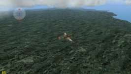
Also, an interesting challenge with the jungle is how the trees overhang and cover everything. Having spent some time in PNG and flown over some of those jungles, there's a lot of those streams you'd never know were there.
rbp71854
PTO Solomons ,PTO Rising Sun, ETO Expansion
Yes it is a lot of water. You should see all the amount of swamp areas. I have been using a map generated by gm to create the theater map. Did it for all the theaters in RS. I have used tiff, and png exported maps of the PNG islands and then flood fill the 2 colors in corel. Very difficult to get a high resolution map after processing to extended bmp 555-1.
Wow, that's a lot of water, and great progress Bob! Another thing I have wondered about is the possibility of creating a hi-res in game map based on the theater creation files. Is it possible to put those shape files into some sort of very large bitmap or jpg?
Also, an interesting challenge with the jungle is how the trees overhang and cover everything. Having spent some time in PNG and flown over some of those jungles, there's a lot of those streams you'd never know were there.
Pat Pattle
SOH-CM-2025
Hi Bob, 
On that list, are the co-ords correct for the new map? Am assuming they are but just wanted to check!
On that list, are the co-ords correct for the new map? Am assuming they are but just wanted to check!
rbp71854
PTO Solomons ,PTO Rising Sun, ETO Expansion
The coordinates are from 2 different sources, Pacific Wrecks and Airdromes Guide of Southwest Pacific published by FEAF 1944.
Now the map will be needing tweaking once all the bits and pieces are put into a theater. The present coastline of the map was produced by using 1945 US Army army topos. Some of the scanned topos were skewed some so there will be some problems that will require tweaking.
Right now I have 3 different sets of alt_xxx.bmp maps ready to see which ones are best.
Clive you have now been drafted into the FEAF.
Hi Bob,
On that list, are the co-ords correct for the new map? Am assuming they are but just wanted to check!
Attachments


sixstrings5859
Charter Member
Oh Yeah ! Keep up the good work. Thank you ! Regards, Scott
rbp71854
PTO Solomons ,PTO Rising Sun, ETO Expansion
Work continues. Its a slow slog right now. Working on dirt roads and dirt trails. Each line has to be manually done. Not many roads in the 1940's on these islands. Mostly native trails linking the various villages, plantations and missions. The brown lines are the roads and the green lines are the trails.
Attachments

rbp71854
PTO Solomons ,PTO Rising Sun, ETO Expansion
I am using the 1945 US Army topos as the source, tracing the map. I am also using a shape file of the 1970's when the topo and shape match, to decrease the need to trace out the road vector.
Some cases I am finding it is easier to create a straight line then go back and insert vertices to match the curves.
Some cases I am finding it is easier to create a straight line then go back and insert vertices to match the curves.
rbp71854
PTO Solomons ,PTO Rising Sun, ETO Expansion
rbp71854
PTO Solomons ,PTO Rising Sun, ETO Expansion
I have run into a major snag, in PNG. The Rabaul area has major phantom islands when placing the Lakunai airfield. I have tried all different flattening tricks to try to eliminate them to no avail. I could flatten the whole area as was done before, but one of the reasons for redo was to get terrain elevations in the Rabaul area.
So right now the theater is on-hold in the hopes that I can come up with some clever solution or if not it the existing work will be abandoned.
So I am off to work on getting individual theaters of Pearl and China uploaded. I also have another thing that I have started on.

So right now the theater is on-hold in the hopes that I can come up with some clever solution or if not it the existing work will be abandoned.
So I am off to work on getting individual theaters of Pearl and China uploaded. I also have another thing that I have started on.