• There seems to be an uptick in Political comments in recent months. Those of us who are long time members of the site know that Political and Religious content has been banned for years. Nothing has changed. Please leave all political and religious comments out of the forums.

    If you recently joined the forums you were not presented with this restriction in the terms of service. This was due to a conversion error when we went from vBulletin to Xenforo. We have updated our terms of service to reflect these corrections.

    Please note any post refering to a politician will be considered political even if it is intended to be humor. Our experience is these topics have a way of dividing the forums and causing deep resentment among members. It is a poison to the community. We appreciate compliance with the rules.

    The Staff of SOH

  • Server side Maintenance is done. We still have an update to the forum software to run but that one will have to wait for a better time.

A Race Event: Airfields of the Southwest Pacific II.

Wow - the original flight model is waaaay too hot!! 300 KTAS at critical altitude of 17,000. I did a quick mod to the airfile (roughly doubled the CD0 "drag at zero lift" figure to 0.058), which brought it down to around 230 KTAS at 17,000, but still enough thrust to get airbourne fully loaded. But if you've got a realistic airfile for the Betty that would be great. :encouragement:

Rgr that Martin. I modified the FM a few years ago, which brought it down to 249 kts at 17000. According to Rene Francillon's book "Japanese Aircraft of the Pacific War", an excellent resource, BTW, it should be closer to 230, which sounds like the FM you just made is better than mine. I've made a NOTAM declaring that this plane must use the revised FM, which is attached. This is the one we allowed in previous events. Can you send me the FM you created?
 
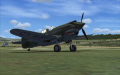
Ill be entering another aircraft for the flight back. A2A P40B model. FSX. Default real weather. The paint by pilottj, might look a little familiar.
 

Attachments

  • 2015-8-18_20-20-51-577.jpg
    2015-8-18_20-20-51-577.jpg
    57.7 KB · Views: 0
Tested in clear WX, Max fuel, climb to it's best power altitude, 15000ft, full throttle, 35MP, 2600rpm, max continuous power, not recommended to go any more, gives 282TAS.
 
Question for the race committee

Down safely at HFD...but a bit confused. Why is the weather so nice? Jeppesen shows clear skies with 50 mile visibility. I tried RealWXLite and got some clouds and 10 mile visibility, and REX weather had me in rain and low visibility. Had I been using REX or RealWXLite I truly believe I would have had a much more difficult time finding the airstrip. A puzzler that I will leave for the race committee.
 
Tested in clear WX, Max fuel, climb to it's best power altitude, 15000ft, full throttle, 35MP, 2600rpm, max continuous power, not recommended to go any more, gives 282TAS.

I'll run another test on this one, just to double check. Here's what I got:

Altitude: 16,000.000
KIAS: 256.422
KTAS: 318.320
Mach: 0.510
Gross WT (lbs): 7,138.738
Fuel (lbs): 948.000
Fuel Flow (PPH): 552.087
Range (NM): 547.400
MP (inces): 43.783
RPM: 2,990.008

NOTE: This is the old WoP P-40B. Is yours the new Accusim version?
 
Down safely at HFD...but a bit confused. Why is the weather so nice? Jeppesen shows clear skies with 50 mile visibility. I tried RealWXLite and got some clouds and 10 mile visibility, and REX weather had me in rain and low visibility. Had I been using REX or RealWXLite I truly believe I would have had a much more difficult time finding the airstrip. A puzzler that I will leave for the race committee.

You're probably right about the different weather gathering systems FS uses. One of these days we'll have to come up with a system where by everyone is getting the same "real weather". For this event we'll stick to the current rules.
 
You're probably right about the different weather gathering systems FS uses. One of these days we'll have to come up with a system where by everyone is getting the same "real weather". For this event we'll stick to the current rules.
Thanks for the clarification. I'll stick with default "real weather" for the rest of this. Perhaps I'll fly the reverse route with another weather engine.
 
I don't know why but the REX weather always seems to be the exact opposite of Jeppesen weather. I very quickly stopped using REX weather way back in REX v1 and have not used it since. It's great for creating custom weather themes but useless for any real weather simulation.
 
I think that's referring to the airport charts for FSX that Jeppesen used to provide, it has nothing to do with the weather data side.
 
I'll run another test on this one, just to double check. Here's what I got:

Altitude: 16,000.000
KIAS: 256.422
KTAS: 318.320
Mach: 0.510
Gross WT (lbs): 7,138.738
Fuel (lbs): 948.000
Fuel Flow (PPH): 552.087
Range (NM): 547.400
MP (inces): 43.783
RPM: 2,990.008

NOTE: This is the old WoP P-40B. Is yours the new Accusim version?

Yep, the Accusim version.
A bit slower, but that's ok.
A lot more to manage, should be interesting.
 
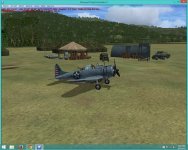
Restarting with a different aircraft. Vertigo SBD Dauntless in FSX SE. Flying the version with the engine failure gauges installed.

attachment.php
 

Attachments

  • flt 19-2015-aug-20-001.jpg
    flt 19-2015-aug-20-001.jpg
    89.8 KB · Views: 0
Willy, I've reset your entry in the race database. Ready to start over in SBD. Nice ride too!
 
Thanks Paul! Just did a couple of legs and let's just say that the engine failure gauge has been well tested....
 
Down safely at HFD...but a bit confused. Why is the weather so nice? Jeppesen shows clear skies with 50 mile visibility. I tried RealWXLite and got some clouds and 10 mile visibility, and REX weather had me in rain and low visibility. Had I been using REX or RealWXLite I truly believe I would have had a much more difficult time finding the airstrip. A puzzler that I will leave for the race committee.

You're onto something here. I've been getting the same clear weather in the same area. Not a cloud in the sky. Just like I have clear weather selected. Went to RealWXLite, and have many clouds. Big giant ones. In FS9 it seems that when the sim can't get reliable weather, it defaults to massive fog and 0.2 NM visibility. This would always happen around deepest darkest Africa and the India. In FSX, it seems the sim default s to clear if it can't get good weather data.
 
A mystery surrounded by a conundrum. Anyway, I think I'll fly the return (reverse) trip using the Manfred C-47 (with the GPS turned off, of course...unless there's a long anticipated vintage virtual cockpit released in the next week or so) using FSX:SE with RealWXLite.
 
Back
Top